ACEINNA, one of the world’s leading developers of inertial based guidance and navigation systems for autonomous vehicles and devices, today announced the commercial availability of OpenARC, a complete, precise positioning hardware & software platform that offers easy system integration of GNSS corrections with high performance INS and RTK hardware. OpenARC is powered by Point One Navigation, a visionary leader delivering precise positioning for the next generation of transportation.
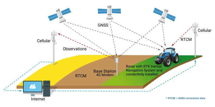
Autonomous vehicle systems require position accuracy better than 10cm to achieve the performance targets and safety goals critical in autonomous applications. Unfortunately, GNSS alone falls short, enabling only meter level position accuracy even under ideal operating conditions. A navigation system that includes an RTK positioning engine and GNSS corrections delivered from a ground-based network of secure base-stations will reliably improve position accuracy to centimeter level accuracy.
The streamlined OpenARC positioning platform combines Point One’s Polaris GNSS correction service with ACEINNA’s OpenRTK330 hardware and software solution for developers of autonomous systems in trucking, precision agriculture, construction, mapping, surveying, and robotics. OpenARC provides high precision and confidence in positioning and localization applications, enabling centimeter level accuracy for challenging tasks such as lane keeping, precision agricultural guidance, and UAV landing maneuvers.
OpenARC is integrated into the OpenRTK330LI navigation module to provide a secure, vertically integrated, and easy-to-use positioning platform. OpenARC offers an easy registration and activation process, and is very scalable, supporting single unit installations to high-volume deployments.
 OpenARC is powered by Point One’s proprietary Polaris GNSS cloud correction service built from the ground up for the needs of modern automotive and robotics customers. Polaris delivers superior station density in areas where operators need it the most, including urban centers and suburban surrounding areas, enabling cold convergence times of under 10 seconds – the fastest of any network solution available.
Polaris provides continuous position monitoring and is the only network that tracks all modern satellite constellations, leading to industry best accuracy and confidence. Fully owned by Point One, the Polaris network uses the latest in base station technology including advanced anti-jam, interference mitigation, security, and integrity monitoring. Its powerful cloud-based correction architecture allows for GNSS corrections in Real Time Kinematic (RTK) or State Space Representation (SSR) configuration. Its open-source interfaces demonstrate compatibility with receivers and chipsets from leading providers. The service is also compatible with any NTRIP/RTCM3 compliant receiver.
“We are excited to launch OpenArc, the most reliable, turn-key and affordable precise positioning solution on the market,” said Dr. Yang Zhao, Chairman and CEO of ACEINNA. “OpenARC integrates high performance inertial navigation hardware & algorithms, with Point One’s unique technology, to deliver a complete high performance positioning solution. This enables our customers to optimize their development costs by leveraging our combined expertise, which we now bring to many industries and applications together through our partnership.”
“Point One’s highly adaptable Polaris network is now fully deployed coast-to-coast, supporting many precise positioning and autonomous applications,” said Aaron Nathan, CEO and Co-Founder at Point One. “OpenARC delivers a precise yet affordable corrections-based solution that is easy to use and we are delighted to be working with an innovator such as ACEINNA.”


